Talking about the weather: it’s a national obsession. And why not? It changes so rapidly in this part of the world, and it impacts us every day. We can all relate to checking the forecast before deciding whether to wear a coat or grab an umbrella, but think of all the critical decisions that depend on weather predictions. Should we evacuate this town? Should we delay this space mission? People’s lives and livelihoods rely on accurate weather forecasts.
In this blog post, I’m going to dive into some of the technology that we use to predict the weather, and look at an exciting new development that could revolutionise the field of meteorology: artificial intelligence.
A Brief History of Weather Forecasting
Since the beginning of time, people have tried to predict the weather. At first, with nothing more than prophecy and superstition (and perhaps some rituals to change any unfavourable outcomes). Aristotle was the first to put a bit of critical thinking into his predictions, but it wasn’t until the 17th century that the ideas and inventions of the Renaissance came together to give us the first scientific understanding of the weather. Fast-forward another couple of centuries, and Lewis Fry Richardson throws a bit of maths into the mix to give us our first glimpse of Numerical Weather Prediction. Then, in the 1950s, computers get involved and forecasting as we know it today really takes off.
Numerical Weather Prediction (NWP) is the practice of producing forecasts using deterministic algorithms, built from the physics-based equations that govern real-world weather patterns. These techniques calculate a prediction based on our best theoretical understanding of physical systems. Early numerical models used highly simplified equations, only taking a few variables into account. Over the ensuing decades, these models got more and more complex, incorporating concepts from thermodynamics, fluid dynamics and chaos theory. While many industries could take advantage of the downsizing of computers, the world’s forecasting agencies kept it large; the report you check today will have been calculated by a warehouse-filling supercomputer.
Predictions have become more and more accurate as a result, but this heavyweight hardware comes at a cost. Aside from the great expense of buying one of these machines, vast amounts of energy are required every time a forecast is produced. It has been joked that running a simulation has its own impact on the weather (although most European agencies have done a good job at switching to low-carbon sources). Now consider that a supercomputer will need replacing or upgrading every four or five years, and factor in all the costs and emissions from manufacturing and transport…
So what will come next in the world of weather forecasting? More complex numerical models? Bigger, more powerful supercomputers? Or could there be something a bit more sustainable?
Unless you’ve been off measuring the weather on Mars for the last few years, you will have noticed that artificial intelligence is the hot topic in tech right now. Here at Scott Logic, we’ve kept a keen eye on what’s going on. We’ve built chatbots; we’ve looked at the sustainability of training large language models; we’ve analysed what businesses need to deploy AI and how it might impact architecture. So what are the prospects of using AI for predicting the weather?
Introducing GraphCast
Turns out, it’s looking quite promising. In the last few months, Google have announced GraphCast: an AI model that they claim can make medium-range weather forecasts with more accuracy than traditional NWP methods.
Google wasn’t the first to apply machine learning to the world of weather forecasting, and it’s not the last. Huawei have created Pangu-Weather and NVIDIA have FourCastNet, each with their own underlying flavours of AI. The European Centre for Medium-Range Weather Forecasts (ECMWF) have taken GraphCast as a starting point to build their own model.
For now, I’ll focus on GraphCast. According to Google’s paper, what they’ve created is an autoregressive model, implemented with a graph neural network architecture in an “encoder-processor-decoder” configuration and trained directly from reanalysis data. But what does all of that mean? Let’s break it down.
Autoregressive
As with any AI or machine learning model, GraphCast takes a number of input values, runs them through an algorithm trained on a large dataset, then gives us one or more predicted output values. In GraphCast’s case, the inputs are made up of two sets of weather observations (temperature, wind speed, humidity etc.), separated by six hours; and the outputs are those same metrics, predicted for the next six hours. Each set of metrics covers the whole of the earth’s surface, and contains over two million values.
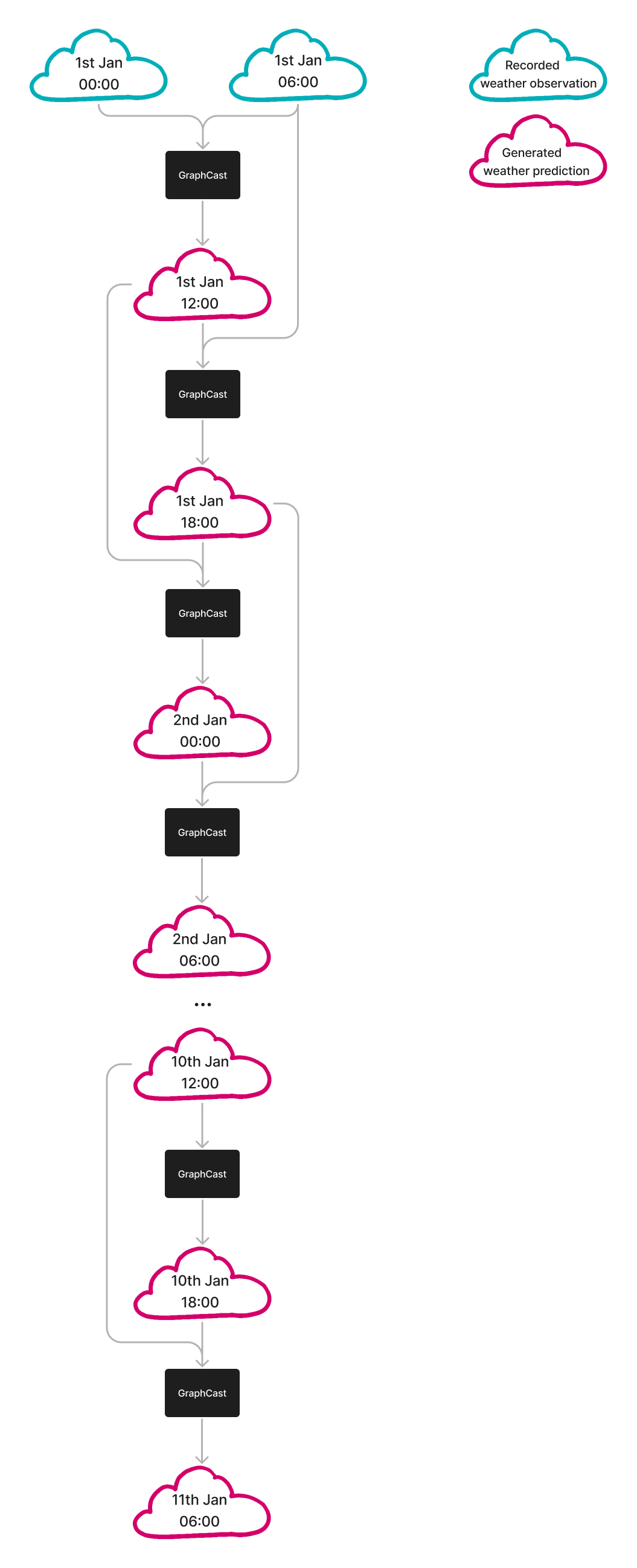
The autoregressive nature of GraphCast means that it can generate further predictions based on its own previous predictions. Say it’s 6 AM; we can make a forecast for midday today by giving GraphCast the current weather conditions, as well as those from six hours ago. We can then use that midday prediction, along with the current observations (6 AM), to forecast for 6 PM today.
We then use our two predictions (midday and 6 PM) to make a third (midnight), and continue feeding back into GraphCast to generate a weather forecast for up to 10 days from now. This process—you can think of it a bit like the Fibonacci sequence—is summarised in the diagram below.

Graph Neural Network
In a standard neural network (formally a Multi-Layer Perceptron, or MLP), we would take an input in the form of a neatly ordered list of numbers (a vector). We would then pass this input through the network one layer at a time, where each layer does the following:
- Multiply each number by a weight, then sum them all together (matrix multiplication)
- Introduce a bit of complexity (apply a non-linear activation function) to produce a new vector
- Feed the new vector into the next layer
This continues through all the layers of the model, propagating information and manipulating the values at each stage, until we get some kind of prediction out the other end.
This type of network works well in a lot of applications, but when we’re modelling weather patterns around the earth’s surface we have a problem. If we put all our input into one vector, we lose information about the geometry of the globe. GraphCast solves this problem using the mathematical concept of a graph.
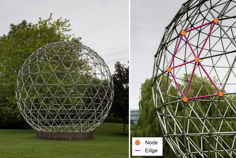
In mathematics and computer science, a graph is a structure made up of nodes (items or objects; data points) connected by edges. Graphs are particularly useful for modelling weather patterns around the earth because we can use them to build up a spherical surface, much like this geodesic dome at the University of Surrey.

This represents the earth’s surface much better than a simple grid of latitude/longitude coordinates, because we’ve now directly linked each point with its closest neighbours.
With our graph representation, we can now make use of a Graph Neural Network (GNN). We have a much more complex input this time: each node has its own vector of information. Any attempt to squash them into one big vector would result in us losing all of that structural information that makes the graph so useful.
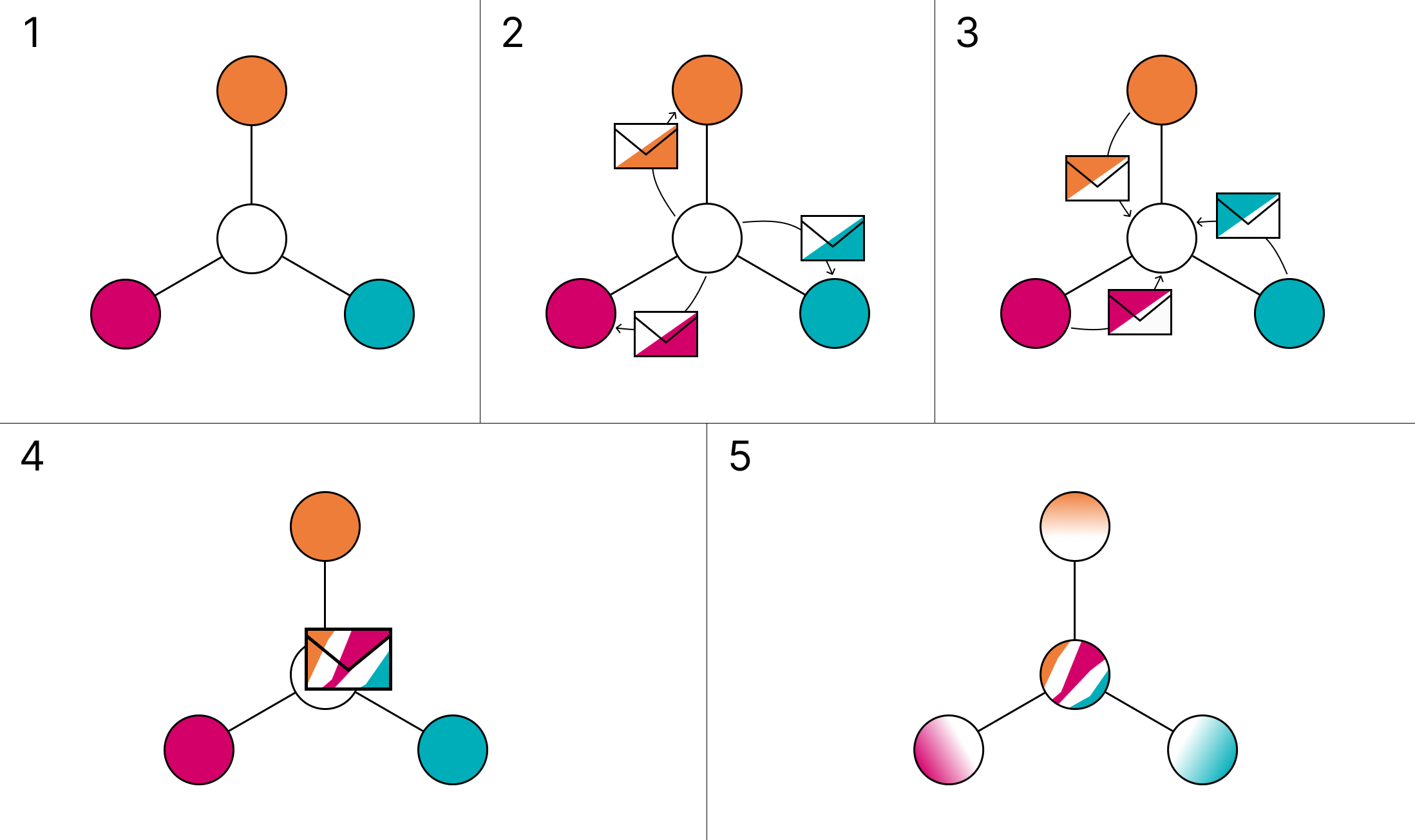
So instead of the MLP process described above, each layer of the GNN propagates information by passing messages between nodes. A node will take information from its neighbour and combine that with its own information (and anything from the linking edge) to create a message. These messages get created and sent between every pair of connected nodes, so each node receives a collection of messages. The node then aggregates all of these messages, and uses the resultant values to update itself.
 How information propagates in a Graph Neural Network.
(1) Input graph with four connected nodes.
(2) Messages are created for each neighbouring node, combining information from the sending and receiving nodes.
(3) Messages are received from each neighbouring node.
(4) Messages are aggregated.
(5) Nodes are updated using the aggregated messages.
So just like weather patterns propagate around the earth’s surface over time, each layer of the network allows information to propagate further and further around the graph. And just as the planet doesn’t deform (at least not significantly enough for weather forecasting), the graph’s structure is always preserved.
Encoder-processor-decoder
As we’ve seen, graph structures can be an excellent way of modelling how weather patterns move around the surface of the earth. But that’s not how our inputs are arranged, and it’s not so useful as an output. GraphCast ingests data on a more conventional latitude/longitude grid, and the first layer in the network is responsible for encoding the information into a graph. This is also learnt behaviour from the training. Likewise on the other end, the final layer decodes the graph back onto a standard grid and—hey presto—there’s your forecast, all ready to use.
Reanalysis Data
As with any machine learning approach, GraphCast had to be trained with a good dataset. Fortunately for Google, there is an excellent dataset called ERA5, which is made freely available by ECMWF. They have produced a video on reanalysis that neatly explains how the data is created (from which I’ve borrowed the images below), but this is the process in a nutshell:
Start by collating recorded weather observations from around the world, going back as far as 1940. These measurements are patchy and not always accurate, so traditional NWP methods are used to essentially make “forecasts” for the past. This technique, known as Data Assimilation, fills in the gaps and irons out any problematic areas to give us a consistent, complete dataset for every point on the globe over the past 80 years.
 Data Assimilation fills in the missing pieces to create a complete picture of the weather over the past 80 years.
Image credit: Copernicus ECMWF https://youtu.be/FAGobvUGl24
Changing the World, One Forecast at a Time
Whenever I come across a new application for AI, my initial thought tends to be, “that’s pretty cool…but does society really need this?” We’re living in a volatile time, and AI seems to be giving us more problems than solutions: deepfakes, copyright infringements, job insecurities. But using these techniques to predict the weather is something I can get on board with. I described at the start of this post just how important weather forecasting is, and using AI promises us more accurate results as well as more advanced notice of extreme weather events. Not only do the results improve, but we also see a dramatic decrease in energy demands.
The initial training can be pretty intensive (Google used 32 of their Tensor Processing Units for about four weeks), but this is a one-off overhead. Afterwards, a ten-day forecast can be generated in under a minute on a single chip. Compare this with a traditional NWP approach, which could take over an hour on a supercomputer with 260,000 cores. NVIDIA reckon that FourCastNet uses about 12,000 times less energy to generate a ten-day forecast than the supercomputer used by the ECMWF.
With less reliance on their supercomputers, forecasting agencies may need to invest in some new data engineering infrastructure. This could be an ideal opportunity for them to migrate to the cloud (pun very much intended) and perhaps to overhaul some of their legacy systems.
This is the End
The End of Supercomputers?
Clearly not, but there are other high-performance computing applications that could take advantage of machine learning. We’re already seeing this kind of progress in fields such as computational chemistry and drug discovery, astrophysical simulation, computational fluid dynamics, and structural mechanics.
The End of NWP?
With the dawn of AI-based forecasting, will we see the end of Numerical Weather Prediction? This seems unlikely to me, but what we might start to see is a refocusing of what NWP is used for. Machine learning can be great at making predictions on an almost “intuitive” level, but it’s not capable of logical reasoning. So perhaps instead of day-to-day forecasts, traditional NWP will be used more as a research tool to improve our understanding of how weather patterns work. We could also see NWP being utilised for more bespoke weather forecasts—perhaps for high-profile aerospace or military applications—or for the occasional benchmarking of AI-generated outputs.
The End of the Blog Post
Now this one is certain. We’ve seen what currently goes into forecasting the weather, and how artificial intelligence is making waves towards advancing and perhaps revolutionising the process with its potential to improve on both accuracy and energy consumption.
Given humanity’s desire and need to predict the weather, I look forward to seeing how this area of development evolves over the coming years. Let’s keep talking about the weather.