Firstly add all bands into the QGIS map that is required in raster composition. For this tutorial I created True Color band composite using Sentinel-2 satellite imagery. For that I added band 4, 3 and 2 as shown in figure 1.
 |
| Figure 1. Sentinel-2 Satellite Imagery Bands 4,3 and 2 |
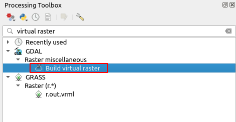
Then in the Processing Toolbox, search for virtual raster. It will appear under the GDAL tool as seen in the figure 2.
 |
| Figure 2. GDAL Build virtual raster tool |
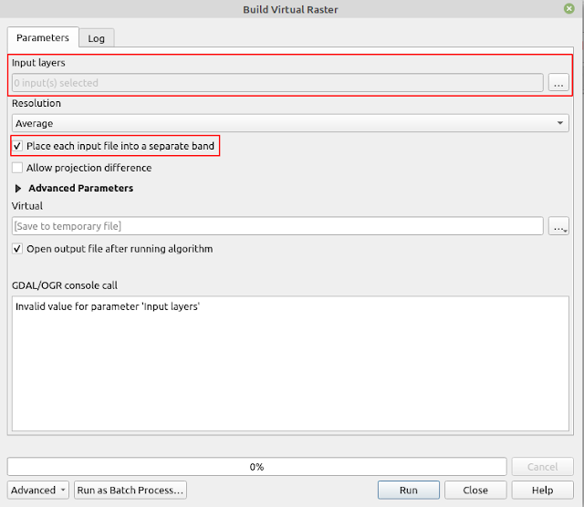
Open the Build virtual raster tool by double clicking it. The tool window appears as in figure 3. Click the Input layers button to select all images required. Make sure to sort them in the right order. For True Color image composition the order is 4-3-2. Make sure band-4 on the top, followed by band-3 and band-2 at the bottom as in figure 4. If you found they are in the wrong order. You can sort it by drag and drop.
 | ||||
Figure 3. Build Virtual Raster Window |
 |
| Figure 4. Band order for image composition |
Back to the main window. Before running the tool, make sure to check Place each input file into separate band option. The image band composite result can be seen as in figure 5.
 |
| Figure 5. True color band composite |
That's all the tutorial on how to create image band composite in QGIS using GDAL Build virtual raster tool. Using the tool we can create many band compositions to get a new visualization that helps us to feature specific objects in a remote sensing task. Hope this helps. Thanks!
